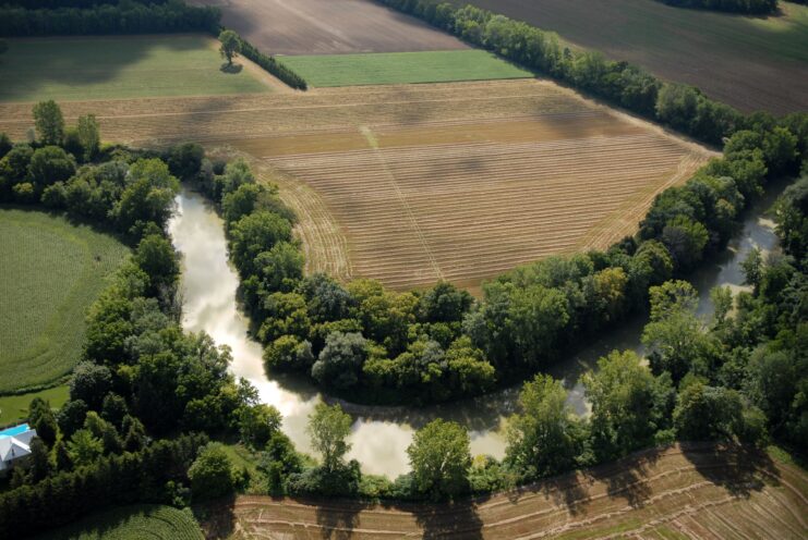
Appropriate land-use practices are critical for the management of watersheds to ensure that the transport of sediment, nutrients and other pollutants to coral reefs is minimised. In the Mesoamerican region, 300,000 hectares of land is allocated to the production of banana, oil palm, sugar cane, citrus, pineapple crops, and mariculture. The residues of chemical products used in these industries drain through the rivers and streams that make up the watersheds leading directly to the coral reefs.
This component gathered information on the potential impact of different land use and development options in the region, to:
- Link patterns of land use within watersheds to the impacts at coral reefs, and identify those reefs at greatest risk.
- Adapt tools to forecast potential future trends, evaluate different policy or development options, and facilitate improved management decision making within the region.
- Form new relationships and strategic alliances with key stakeholders such as the local government, large agro-industrial companies and independent farming communities
- Use the results of the models and diagnostic tools to help educate and encourage key stakeholders to adopt a suite of ‘Better Practices’ to reduce impacts on the coastal and marine resources.
In 2004, the ICRAN-MAR initiated an effort to develop better information on the effects of land cover change and agricultural activities on sediment and nutrient delivery on coastal waters in the region. Having assembled a rich geographic database on physical characteristics of the MAR region, a hydrologic analysis of runoff (sediment/nutrient delivery, total suspended solids) to coastal waters was implemented.
This was coupled with a circulation model to estimate sediment transport to the reef. The hydrologic model has been implemented on several scenarios of past, current and future land cover change, to evaluate impact of human activities on sediment and nutrient delivery, as well as the implications of future development paths and policy options. The data and tool have been transferred to partners in the region and are available for anyone to apply to analysis of land-based threats to the MAR.
The World Resources Institute (WRI) led this collaborative effort to evaluate the land-based threats posed to the Mesoamerican Reef (MAR) from human alterations of the landscape. The analysis quantifies sediment and nutrients coming from over 400 watersheds that discharge along the MAR. In addition, the analysis provides estimates of the increases in sediment and nutrient delivery that have resulted from human activities, and predictions of future sediment and nutrient delivery in 2025 based on varying land-use scenarios. The purpose of the analysis is to inform land-use planning, agricultural policy and practice, conservation priorities, and coastal threat mitigation efforts. This analysis is the first of this scope and level of detail for the MAR region.
These tools and analysis results are being used to encourage key stakeholders to adopt a suite of ‘Better Practices’ to reduce impacts on the coastal and marine resources; to establish close relationships with key agro-industries to work jointly in identifying and implementing better management practices at field level to reduce the presence of priority pesticides in the MAR marine environment; and to control soil erosion from major commercial agricultural sectors while sustaining productivity. Banana producing companies, sugarcane and citrus growers associations from Mexico, Belize, Guatemala and Honduras have joined these efforts.
The analysis and results are available in English and Spanish. High resolution maps of key results are also available in both languages. This information is also available on data CD, Watershed Analysis for the Mesoamerican Reef, WRI/ICRAN MAR project, 2006, which can be requested through WRI or ICRAN. The GIS data are also available online via the Mesoamerican Regional Visualization and Monitoring System (SERVIR) Data Portal at or
Reports
- Proceedings of the Watershed Management Workshop, Belize. August 2006
- P1: Mesoamerican Reef, Threats and Health Assessment
- P2: Evoluciуn del Concepto sobre Manejo de Cuencas en La Regiуn Mesoamericana
- P3: Scenario Development for the MAR Region
- P4: Land Use Change Modelling for Scenarios of the MAR Region
- P5: Land Use Change and Watershed-based Impacts to the Mesoamerican Reef – An Analysis under the ICRAN Partnership
- P6: Watershed Analysis of the Mesoamerican Reef Region: Application of the Nonpoint Source Pollution and Erosion Comparison Tool (N-SPECT)
- Review of ICRAN MAR Watershed Modeling Outputs: Belize Group
- Review of ICRAN MAR Watershed Modeling Outputs: Guatemala Group
- Review of ICRAN MAR Watershed Modeling Outputs: Honduras Group
- Review of ICRAN MAR Watershed Modeling Outputs: Mexico Group
- Hydrologic Modelling of the Watersheds Discharging Adjacent to the Mesoamerican Reef. December 2006 (pdf) – Eng / Esp
- Sampling, Biomarker and Contaminant Chemical Target Analysis Protocol – Assessing the Effectiveness of Agricultural Better Management Practices in the Mesoamerican Reef. December 2005 (Pdf)
- Land Use Change Modelling for Three Scenarios for the MAR Region – Technical Report. October 2006 (Pdf)
- Belize Coastal Threat Atlas. May 2005 (Pdf)
- Contaminant Monitoring Protocol: Assessing the Effectiveness of Agricultural Better Management Practices in the Mesoamerican Reef
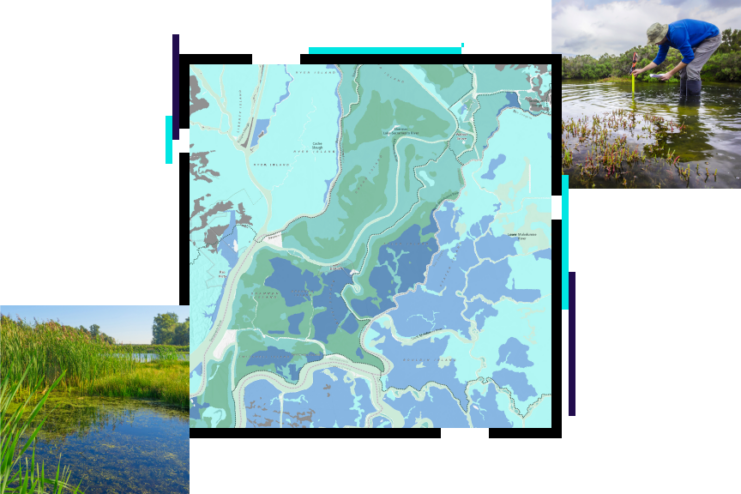
Maps
The following maps provide images summarising some of the key results of the Watershed Analysis for the Mesoamerican Reef:
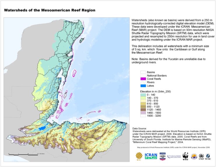
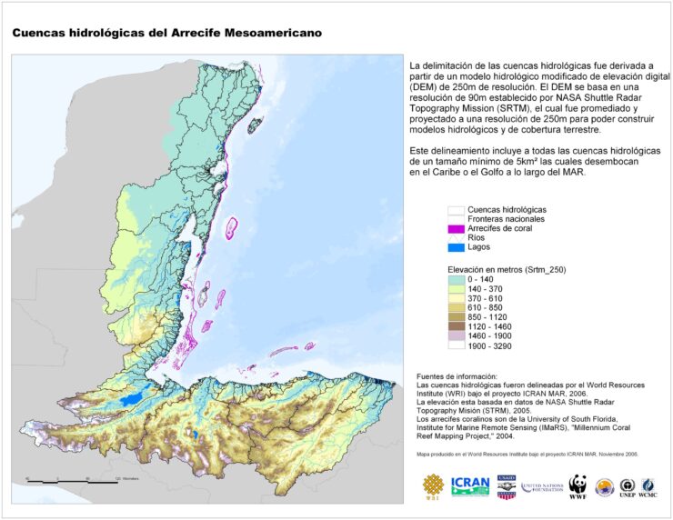
1a. Watersheds of the Mesoamerican Reef Region (with elevation data)
(English, Espaсol)
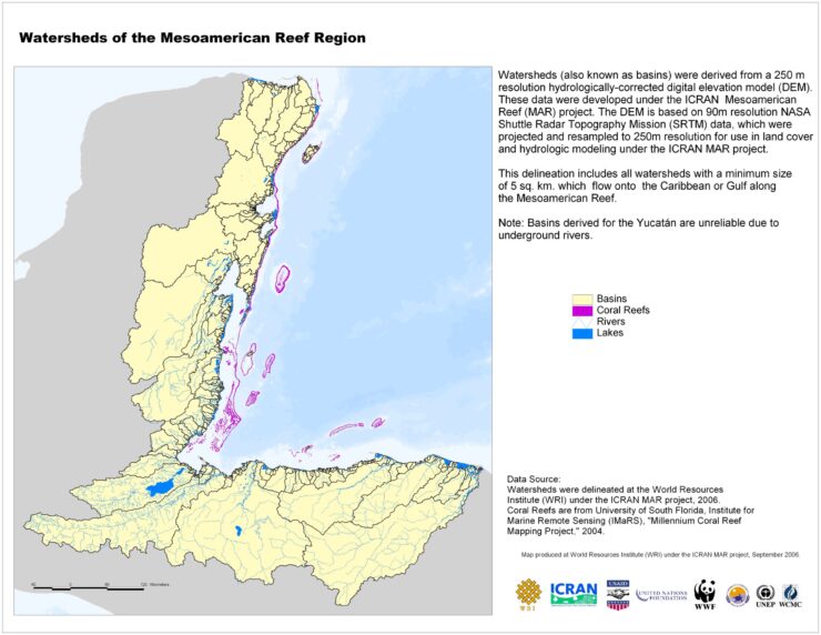
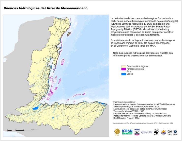
1b. Watersheds of the Mesoamerican Reef Region (without elevation data)
(English, Espaсol)
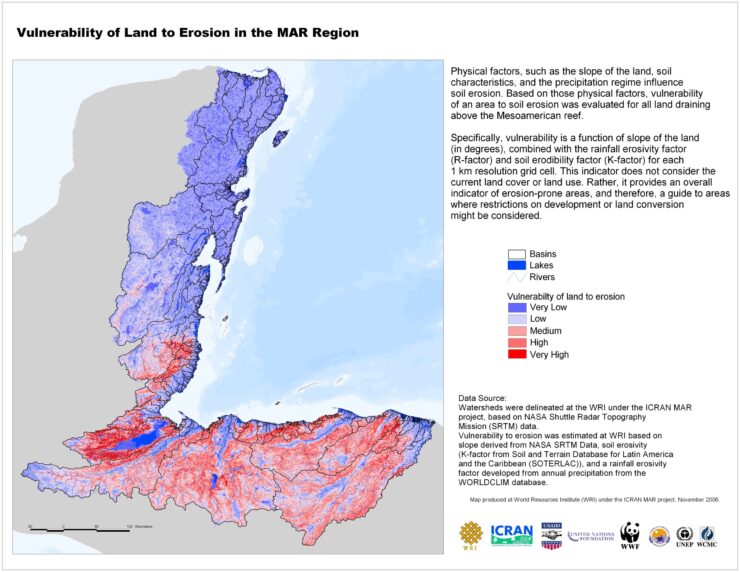
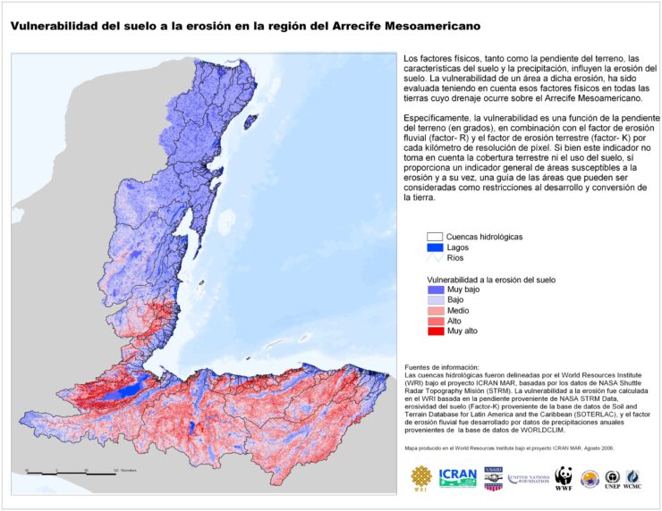
2. Vulnerability of Land to Erosion in the MAR Region
(English, Espaсol)
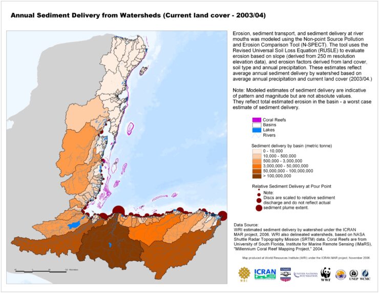
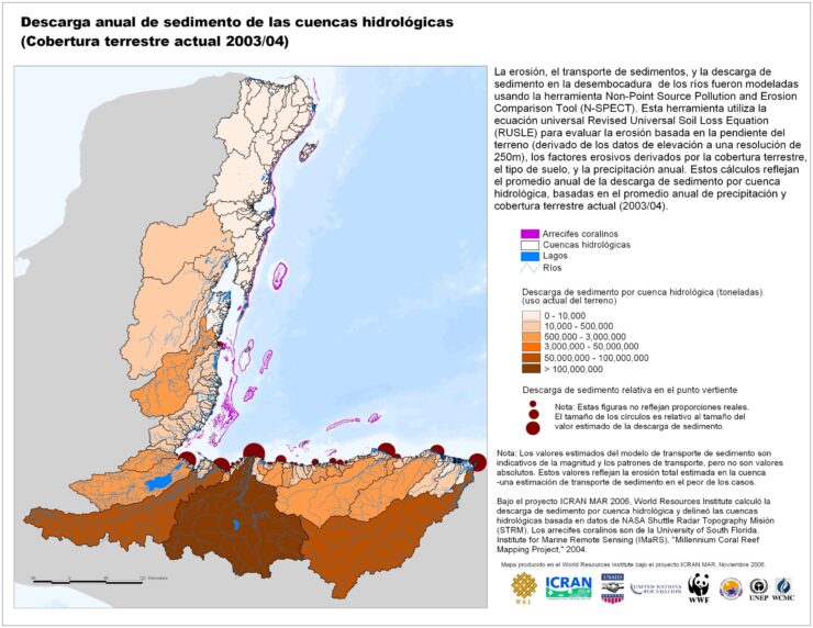
3. Annual Sediment Delivery from Watersheds (current land cover)
(English, Espaсol)
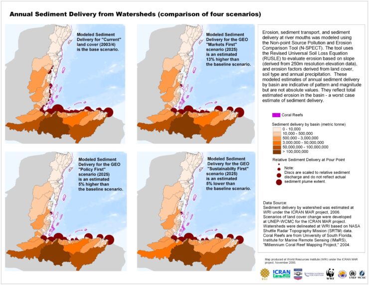
4. Annual Sediment Delivery from Watersheds (comparison of four scenarios)
(English, Espaсol)
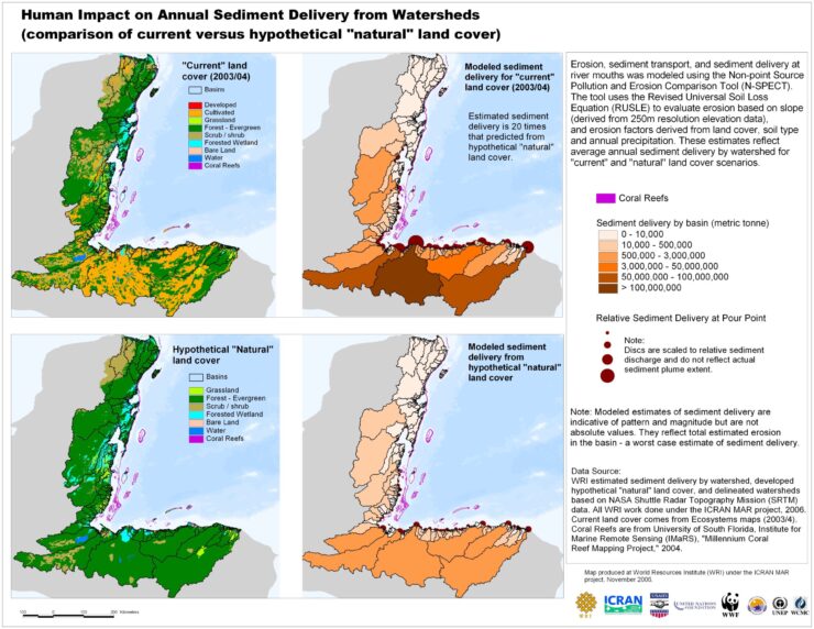
5. Human Impact on Annual Sediment Delivery from Watersheds (comparison of current verses hypothetical ‘natural’ land cover)
(English, Espaсol)
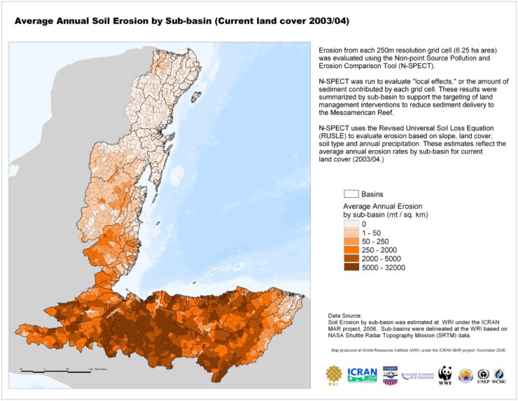
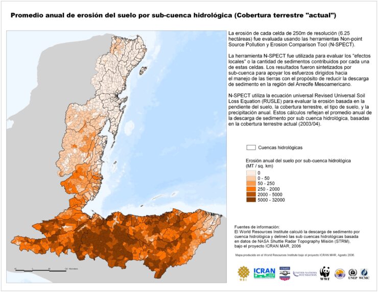
6a. Average Annual Soil Erosion by Sub-basin (current land cover)
(English, Espaсol)
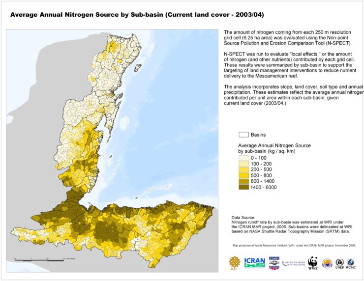
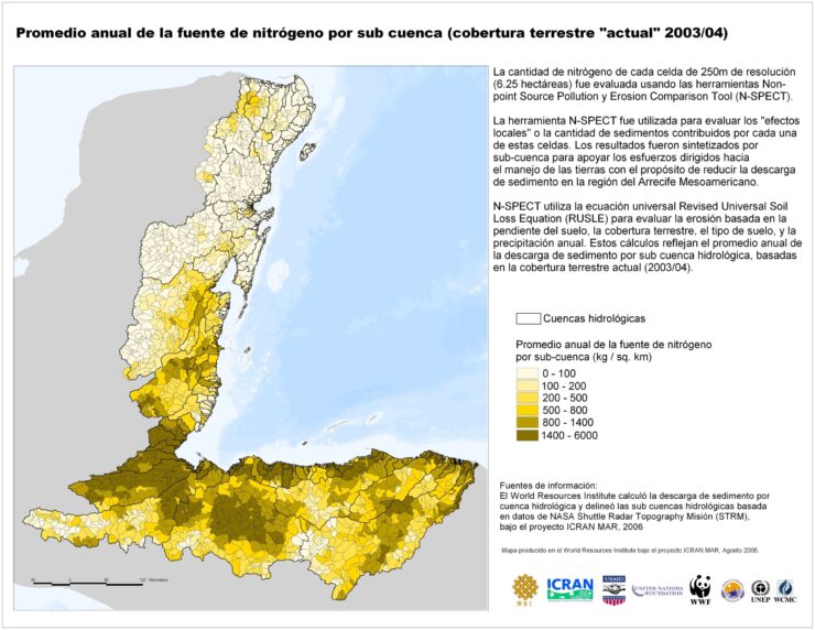
6b. Average Annual Nitrogen Source by Sub-basin (current land cover)
(English, Espaсol)
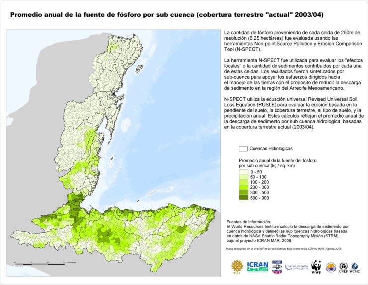
6c. Average Annual Phosphorous Source by Sub-basin (current land cover)
(English, Espaсol)
Download all the maps in a Zip file
(English – 15 MB, Espaсol – 15 MB)
Articles/News
- Press Release – WRI Launches Watershed Analysis for the Mesoamerican Reef (Pdf) – Eng / Esp
- GPA Outreach: Oceans and Coasts (Pdf)
- WWF signs MoU with sugar cane growers in Honduras (Pdf) – Eng / Esp
- WWF signs MoU with citrus growers in Honduras (Pdf) – Eng / Esp
Links to useful resources on this component:
- Reefs at Risk in the Caribbean:
- Mesoamerican Regional Visualisation and Monitoring System (SERVIR) Data Portal:
- Belize Maps (produced by project partners):
- Comparison of national mangrove cover data for 1992 and 2004, showing areas cleared for coastal development in that period: bz_mangrove_clearing_1992-04.pdf
- Comparison of the 90m SRTM-derived slope data with that of national soil / terrain mapping project, conducted by U.K. Overseas Development Administration between 1986 and 1992: bz_slope_maps_comparison.pdf
- Land cleared as of the period 1989-90-92 (from Belize’s first national land use mapping project), showing 0.5 million acres (of 5.6 million acres) of converted lands:
- Land cleared as of 2004 (the most recent national land use data available), showing over 1 million acres of converted lands:
- Other GIS data dissemination links
- Biodiversity and Environmental Resource Data System of Belize: www.biodiversity.bz
- Belize Clearing House Mechanism: www.chm.org.bz


